
# 46406
BUACHE, Philippe (1700 - 1773)
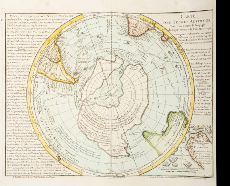
Carte des Terres Australes comprises entre le Tropique du Capricorne et le Pôle Antarctique.
Où se voyent les Nouvelles découvertes faites en 1739 au sud du Cap de Bonne Esperance par les Ordres de Mrs de la Compagnie des Indes. Dressée sur les Mémoires et sur la Carte Originale de Mr le Lozier Bouvet chargé de cette Expedition. Par Philippe Buache de l’Academie R.le. des Sciences gendre de feu Mr. Delisle per. géographe du Roy de la même Acad. A Paris : Sur le Quay de l’Horloge du Palais sous le privilege de l’Academie Rle. des Sciences le 5 Septembre 1739 … Augmentée de diverses vues physiques &c.1754 [1757].
Engraved map, 240 x 310 (image), central fold as issued, original hand colour, a couple of spots of foxing, a fine example of this spectacular map of the southern hemisphere. The central feature of the Buache map is a dramatic rendering of what Buache perceived to be the Antarctic continent landmass under its polar ice. The discoveries of Abel Tasman in what is now called New Zealand are incorporated into this Antarctic continent.
‘Planisphere of the South Pole showing Antarctica and New Zealand, and parts of South America, Australia, Africa, and Madagascar. Rather than a continuous Antarctic landmass, the map shows a large glacial sea at the pole, surrounded by separate landmasses, the larger of which extends to incorporate New Zealand. Has an inset map showing Cape Circoncision, on subantarctic Bouvet Island (now belonging to Norway), illustrations of icebergs off its coast and with a note reading “glaces vues en janvier 1739”. The map is an amended version of a chart presented to the l’Academie Royal des Sciences, to illustrate the discoveries of a 1739 expedition by Lozier Bouvet. At the left margin of the sheet are extracts from an account of Bouvet’s voyage. The map shows descriptive notes and ships tracks, among them the tracks of Magellan (1520), Tasman (1642), Halley (1700) and Dampier (1700). In addition, the map shows the tracks of the ships the Aigle, the Marie and ‘Espagnol le Lion, 1756’. The map is plate XIV, taken from the atlas, Cartes et tables de la géographie physique or naturelle.
Philippe Buache, (b.1700- d.1773), was the successor to Guillaume de L’Isle, and became among the most prominent French cartographers of the 18th century. Buache often abandoned de L’Isle’s scientific approach, favouring instead a ‘theoretical cartography’, and thus produced fantastical maps, not related to scientific of geographic fact. Tooley notes that this is particularly evident of his coverage of the Australasian and Antarctic regions. Source: Tooley’s Dictionary of Mapmakers, A-D, 1999; Tooley, R.V. The Mapping of Australia and Antarctica, 1985.’
– State Library of New South Wales

