
Cartography
-
# 50497
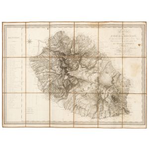
BORY DE SAINT-VINCENT, Jean-Baptiste (1778-1846)
Carte de l’île de la Réunion, par Bory de S.t Vincent, officier d’État-Major, pour servir à son Voyage dans quatre îles des mers d’Afrique;
Dédiée à son Excellence le Maréchal Berthier, Ministre de la Guerre. [Paris, Dépôt de la Guerre, 1804]. Engraved map, dissected into eighteen panels and laid on linen, 645 x 860 mm., some light stains and wear along the folds, title label with manuscript Carte de Bourbon, a very good example. The very rare separately issued version …
-
![[IMPERIAL RUSSIA] St.-Pétersbourg et ses environs : guide pratique illustré. (With an extra map, issued only to conference delegates)](https://douglasstewart.com.au/app/uploads/2026/06/2026_DSFB_3631-300x300.jpg)
# 50457
[Société M. O. Wolff]
[IMPERIAL RUSSIA] St.-Pétersbourg et ses environs : guide pratique illustré. (With an extra map, issued only to conference delegates)
At head of title: Conférence Internationale des Horaires des Trains a St.-Pétersbourg pour le service d’hiver 1899-1900. St.-Pétersbourg & Moscou : Société M. O. Wolff, Imprimeurs-Editeurs-Libraires de la Cour Impériale, 1899. Small octavo (185 x 130 mm), original red cloth decorated in blind and lettered in gilt (nice and bright); half-title leaf, photographic frontispiece, title-leaf, …
-
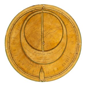
# 49136
DESROYS, Ginot
Planisphère mobile.
Au moyen du quel on peut apprendre l’Astronomie seul et sans le secours des Mathématiques. Imité de l’Anglais par Melle. Ginot Desroys. Prix 4 f. Paris : chez Bachelier, 1847. Planisphere, 355 mm in diameter, comprising four die-cut discs (or volvelles) of engraved paper over card, pointer, central screw, and holes for suspension at the two …
-
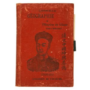
# 50492
RICHARD, L., S.J.
Géographie de l’Empire de Chine (Cours Inférieur) = Fa wen Chung-kuo kʻun yü lüeh chih
Chang-hai [Shanghai] : Imprimerie de la Mission Catholique a l’Orphelinat de T’ou-Sè-Wè, 1905. First edition. Small octavo (187 x 127 mm), publisher’s tan cloth with pictorial device and lettering in English and Chinese in black, spine lettered in English and Chinese in gilt (flecking to both boards and spine); front pastedown bearing the original owner’s …
-
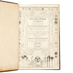
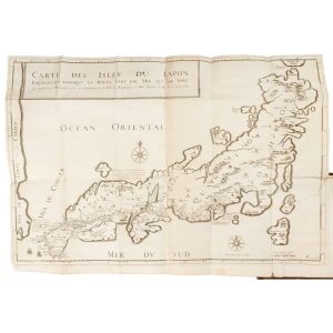
# 48351
KAEMPFER, Engelbert (1651-1716)
The History of Japan : giving an Account of the Antient and Present State of Government of that Empire; … together with a Description of the Kingdom of Siam.
London : for the Publisher, and sold by T. Woodward and C. Davis, 1728. First edition in English, second issue (with the ‘Second Appendix’). Two volumes, folio, contemporary full speckled calf with double gilt rule (boards a little scuffed), expertly rebacked with new spines in period style, spines in compartments with raised bands, contrasting leather …
-
# 49506
TAVERNIER, Jean-Baptiste
Recüeil de plusieurs relations et traitez singuliers & curieux
de J.B. Tavernier, escuyer, Baron d’Aubonne, qui n’ont point esté mis dans ses six premiers voyages : divisé en cinq parties. I. Une relation du Japon, & de la cause de la persecution des chrestiens dans ses isles … II. Relation de ce qui s’est passe dans la negociation des deputez qui ont este en Perse …
-
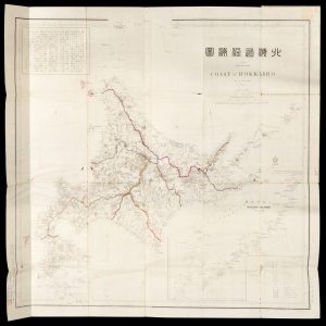
# 49935
吉田晋 / YOSHIDA, Susumu
北海道沿海圖 / Japan Yezo Islands Coast of Hokkaido. The 16th year of Meiji 1883
[Tokyo], Matsui Chūbē, Meiji 16 [1883] / [東京], 松井忠兵衛, 明治 16 [1883]. Lithographed map, outline hand colour, 77 x 75 cm, folded into cover 23 x 16 cm, mounted in cover boards with title label, a few small worm holes and tears, a very good copy. Scarce separately issued map in English and Japanese of …
-
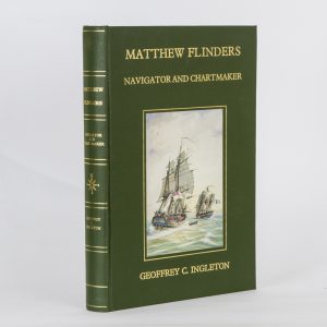
# 50219
INGLETON, Geoffrey C.
Matthew Flinders : navigator and chartmaker
Foreword by HRH The Prince Philip Duke of Edinburgh. Guildford, Surrey [U.K.] : Genesis Publications in association with Hedley Australia, 1986. Large quarto, publisher’s green cloth boards with gilt lettering to upper board and spine, upper board with pictorial onlay of Flinders’ Investigator and Baudin’s Le Géographe, front endpapers with map, rear endpapers illustrated with …
-

# 50164
Anon.
Plan of the city of Mantua, Italy, published in Tbilisi, Georgia
Lithographed map, 195 x 260 mm (image), folds as issued, dates circa 1900. Text in Georgian. A cartographic curiosity.
-

# 50155
Hawaii. The big island of the Hawaiian group
Honolulu : Hawaii Tourist Bureau, circa 1950. Single sheet, folded to make a tourist brochure on the Big Island, map.
-
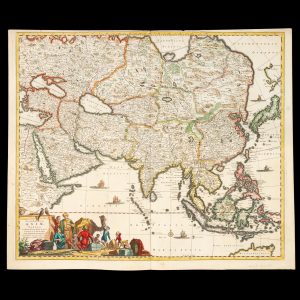
# 39617
de WIT, Frederick (1630-1706)
Accuratissima totius Asiae tabula : in omnes partes divisa, de nova correcta, ac in lucem edita
per Fredericum de Witt Amstelodami cum privilegio D.D. ordinum Hollandiae Westristacqs ; F. de Wit excudit. [Amsterdam : Frederik de Wit, circa 1688]. Copperplate engraving on paper, 58.0 cm in diameter, on sheet 51.0 x 61.0 cm, original hand colouring, a couple of paper reinforcements verso, a very good copy. A fine large format seventeenth century …
-
![[MAP] Karte von Australien oder Polynesien : nach den Zeichnungen, Reisebeschreibungen](https://dsfb-wp.s3.ap-southeast-1.amazonaws.com/app/uploads/2016/11/16170000/2015_DSFB_0724-300x219.jpg)
# 10394
WEIGEL & SCHNEIDERSCHEN
[MAP] Karte von Australien oder Polynesien : nach den Zeichnungen, Reisebeschreibungen
und Tagebücher der vorzüglichsten Seefahrer bis 1789 entworffen im Jahr 1792, vermehrt 1796. Nürnberg : in der Weigel und Schneiderschen Handlung mit Kayserl. allergnl. Privil., 1796 [but probably 1804-1808]. Copperplate engraved map with hand colouring, 460 x 650 mm, verso with contemporary title in large, bold manuscript AUSTRALIEN; central vertical fold, as issued; a fine copy. A …
-
![[COOK] Newton’s new & improved terrestrial pocket globe 1817](https://douglasstewart.com.au/app/uploads/2023/06/2023_DSFB_3248-300x300.jpg)
# 40260
NEWTON FAMILY
[COOK] Newton’s new & improved terrestrial pocket globe 1817
London : John Newton, 1st January 1817. Terrestrial pocket globe, 3 inches in diameter, engraved gores with original hand colour over papier-mâché and plaster sphere, the surface in fine order with a recent wax applied for protection, two metal pins resting the globe in the original publisher’s shagreen case, titled Newton’s improved pocket celestial globe, …
-
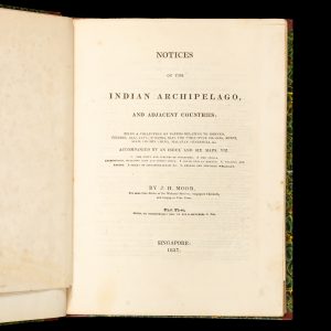
# 48531
MOOR, J[ohn] H[enry] (1802 - 1843)
Notices of the Indian Archipelago, and adjacent countries; being a collection of papers relating to Borneo, Celebes, Bali, Java, Sumatra, Nias, the Philippine Islands, Sulu, Siam, Cochin China, Malayan peninsula, &c.
Accompanied by an index and six maps. Part first [all published]. Singapore : the author, 1837. Quarto (266 x 220 mm), finely bound in period style quarter straight-grained morocco over marbled papered boards, spine lettered in gilt; large hand-coloured folding map of ‘The Town and environs of Singapore, drawn by J.B. Tassin, from an actual …
-

# 20851
THOMPSON, Henry Augustus
The world
[England] : Henry Augustus Thompson, 1853. Manuscript and watercolour map on card with the blindstamp of de la Rue Co, London, 450 x 570 mm (sheet), light surface soiling, old pin holes to corners, fine. A charming and unique manuscript map of the world in two hemispheres, with detailed decorative border vignettes and original hand colour. …
-

# 20853
THOMPSON, Henry Augustus
The world
[England] : Henry A[ugustus] Thompson, December 7th 1855. Manuscript and watercolour map on card with the blindstamp of de la Rue Co, London, 450 x 570 mm (sheet), light surface soiling, old pin holes to corners, fine. A charming and unique manuscript map of the world on Mercator’s projection, with detailed decorative border and original hand …