
Cartography
-

# 20079
GRENET, l'Abbe; BONNE, Rigobert
Atlas portatif general pour servir a l’intelligence des auteurs classiques.
Paris : Jean, circa 1790. Quarto, papered boards (worn, lacking the spine and paper to lower board); preliminary blank loose, engraved title page, 91 double-page copperplate engraved maps by Bonne dated between 1780 – 1800, all with hand-colouring in outline; table (index). Grenet’s atlas of the world with engraved maps by Bonne, Ingenieur-Hydrographe de la …
-

# 42897
GROSS, Alexander
The Jewish Chronicle Map of Israel
Cover title : Map of Israel, including plans of Jaffa – Tel Aviv, Jerusalem, Haifa, the Middle East. London : Geographers’ Map Co. for The Jewish Chronicle, November 1949. Map, printed in colour, 101 x 76 cms, folded and housed in lettered card wrappers (small tears to the corners, and at the point where the …
-

# 41471
DUNN, Samuel (? - 1794)
The description and use, of the universal planispheres ; or, terrestrial and celestial globes in plano.
Being compleat substitutes for a large pair of globes. With their applications, in the solutions of all the capital problems in geography, astronomy, and navigation. Invented and delineated by Samuel Dunn. London : Printed and published (according to an Act of Parliament) for the author, and W. Owen, 1759. Second edition, with additions and improvements. …
-

# 32074
WEYGAND, F. J.
Globe artificiel et mécanique a l’usage du petit géographe.
Amsterdam ; La Haye [Netherlands] : F. J. Weygand, [ca.1840]. Collapsible globe in 6 gores, engraved with hand colouring, laid down on thin card, each gore 170 x 70 mm (irregular); in fine condition with vivid original colour, Australia with Terre de Witt, Terre d’Eendracht, Cape Leeuwin, Terre de Nuyts, Golfe de Spencer, Terre de Van …
-

# 41409
DISTRICT RAILWAY
Improved District Railway Map of London
London : W. J. Adams & Sons, 1880. Second edition. Large folding map, 66 x 108 kms, printed in colour, folded as issued (a couple of splits along the folds), in illustrated paper wrappers (light edge wear). Scarce early railway map of London. ‘This is a geographic style railway map on linen and card, issued …
-

# 41932
Map of Singapore
With compliments of Adelphi Hotel & Chanrai’s, Singapore’s only exclusive air conditioned men’s shop. Singapore : Chanrai’s, c. 1960. Folding map, printed in colour, 450 x 295, guide to Singapore and advertisements verso. Fine condition.
-

# 41659
BARDIN, William (c.1740-1798)
Wright’s new improved terrestrial globe,
on which the Latitudes and Longitudes of Places are Carefully laid down, with all the New Discoveries Made by the late CAPT. COOK and other current NAVIGATORS to the Present Time. London : William Bardin, 1782. Terrestrial globe, 9 inches in diameter, engraved gores and two polar calottes with original hand colouring over papier mache …
-
![[WORLD MAP] Bankokushnghizu](https://dsfb-wp.s3.ap-southeast-1.amazonaws.com/app/uploads/2017/02/04163400/2016_DSFB_4474-300x221.jpg)
# 41525
Yamanaka Zensaburo
[WORLD MAP] Bankokushnghizu
Japan : (Meiji 14) [1881]. Handcoloured copperplate print, 990 x 700 mm, folding to 130 x 180 mm, some silverfishing and creases with some splitting, both repaired with Japanese tissue. A map of the world on Mercator’s projection by Japanese cartographer Yamanaka Zensaburo. Obviously derived from European sources, it shows the voyages of famous explorers …
-
![[ANTARCTICA] Die Gebiete um den Südpol](https://douglasstewart.com.au/app/uploads/2023/08/2023_DSFB_4863-300x300.jpg)
# 40439
FLEMMING, Carl (publisher); HERRICH, A. (cartographer)
[ANTARCTICA] Die Gebiete um den Südpol
Glogau : Carl Flemming, [ca. 1896]. Chromolithographic map, 410 x 480 mm, dissected and laid down on its original linen backing sheet, 420 x 495 mm; shows tracks of the main Antarctic expeditions from Cook (1772-75) to Bull (1894-95); scale 1:40,000,000; light handling wear around the edges, otherwise very good, with old collection stamp and …
-

# 36977
HAWKESWORTH, John (1715-1773); COOK, James (1728-1779); KING, James
The three voyages of Captain James Cook
1. An account of the voyages undertaken by the order of his present Majesty for making discoveries in the southern hemisphere, and successively performed by Commodore Byron, Captain Wallis, Captain Carteret, and Captain Cook, in the Dolphin, the Swallow, and the Endeavour: drawn up from the journals which were kept by the several commanders, and …
-

# 40288
LETAILLE, Charles
Croquis et Souvenirs d’un Artiste, ou détails les plus curieux d’un Voyage Autour du Monde.
Récreation instructive. Dédiée à la jeunesse par Chles. Letaille. Paris : chez les Principaux Mds. de nouveautés pour Etrennes et Cadeaux [Charles Letaille, 30 rue Saint-Jacques], [ca. 1855]. Original box of papered card, 265 x 200 x 30 mm, the lid with embossed gilt border and hand-coloured lithographic onlay depicting a New Zealand scene with Māori; the …
-

# 40251
CRUCHLEY, George F. (1797 - 1880)
Cruchley’s new terrestrial globe, from the most recent authorities, exhibiting the discoveries in equatorial Africa, North Pole, and the new settlements and divisions in Australia, New Zealand, California, Texas &c.
London : G. F. Cruchley, [ca.1862] Terrestrial globe, 12 inches in diameter, engraved gores with original hand colouring over plaster base, graduated equator and ecliptic, the oceans with an analemma, hand-engraved calibrated brass meridian ring, movable brass polar calotte, small area of restoration to the north polar axis, engraved calendrical paper horizon ring with zodiac (in …
-
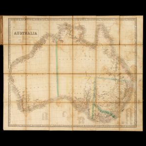
# 40346
George Philip & Son
Australia
[Cover title : New Map of Australia]. London : George Philip & Son, circa 1856. Engraved map, dissected and laid on linen, 52 x 62.5 cm (image), stained, in original publisher’s folding cloth case, worn and stained, with a contemporary presentation inscription. A rare separately issued gold rush map of Australia, showing the counties in …
-
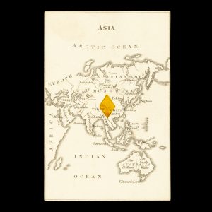
# 24932
ROCK, William and Henry
Playing card with map of Asia including Australia
[London : William & Henry Rock, 1839]. Single playing card (from the deck of 52), 97 x 65 mm, verso blank, recto with engraved map of Asia stretching fro the Arctic Ocean to Van Diemen’s Land, the Australian continent divided between New Holland and New South Wales, with coloured diamond in the centre. From the …
-
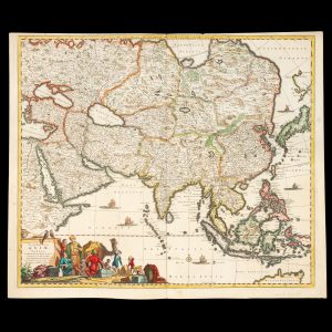
# 39617
de WIT, Frederick (1630-1706)
Accuratissima totius Asiae tabula : in omnes partes divisa, de nova correcta, ac in lucem edita
per Fredericum de Witt Amstelodami cum privilegio D.D. ordinum Hollandiae Westristacqs ; F. de Wit excudit. [Amsterdam : Frederik de Wit, circa 1688]. Copperplate engraving on paper, 58.0 cm in diameter, on sheet 51.0 x 61.0 cm, original hand colouring, a couple of paper reinforcements verso, a very good copy. A fine large format seventeenth century …
-

# 35845
Rand McNally & Co.
Rand McNally 18″ Globe
[Chicago] : Rand McNally & Co., [c.1928]. Chromolithographed paper gores over paper mache base, 18 inches in diameter, oval shaped analemma, engraved brass meridian, wooden horizon ring with paper calendar, four cross-stretchers, on the original Regency revival stand turned wood on tripod base, the legs ending with brass clawed feet A fine, handsome American floor …