
Cartography
-

# 47455
WOODS, Martin et al.
Mapping our world : Terra Incognita to Australia
Canberra, ACT : National Library of Australia, 2013. Oblong quarto, illustrated wrappers, pp. xxix, 256, illustrated. An extraordinary exhibition of manuscript and printed maps of Australia, the Pacific and the world from the medieval period to nineteenth century.
-

# 47321
LEWIS, Meriwether, & CLARK, William
Travels to the Source of the Missouri River and Across the American Continent to the Pacific Ocean. Performed by Order of the Government of the United States in the Years 1804, 1805 and 1806.
London : Longman, Hurst, Rees, Orme, & Brown, 1817. Third English edition. Three volumes, octavo, finely bound by the London firm of Root & Son in half crushed morocco over marbled papered boards, spines in compartments with gilt-lettering, ruled in gilt, top edges gilt, marbled endpapers (binder’s stamps verso), pp. xxvi; (2); large folding map …
-
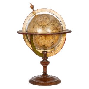
# 46572
DESNOS, Louis-Charles (1725 - 1805); NOLIN, Jean-Baptiste (1686-1762)
Globe terrestre
Dressé sur les Relations les plus nouvelles de Mrs. de l’Académie Royale des Sciences par L. C. Desnos et J. B. Nolin Géographe. Se fait et se vends chez Desnos, rue St. Jacque St. Severin, Quartier de la Place Maubert. Paris, 1760, avec privilége du Roy. Dedié au Roy, par son trés humble trés obéissant …
-
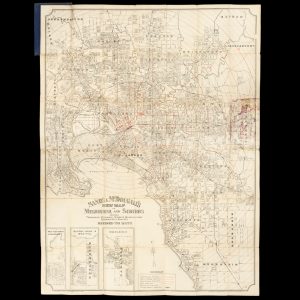
# 47166
SANDS & McDOUGALL
Sands & McDougall’s map of Melbourne and suburbs : showing tramways, railways streets, municipalities quarter mile radii etc. Revised to date
[Cover title : Map of Melbourne]. Melbourne : Sands & McDougall Pty. Ltd., [circa 1911]. Lithographed map, printed in black with red concentric circles, 98 x 74 cm, folded into titled cloth case, lightly marked, offsetting to one panel from the cloth case, a very good copy. An attractive street map of Melbourne extending from …
-
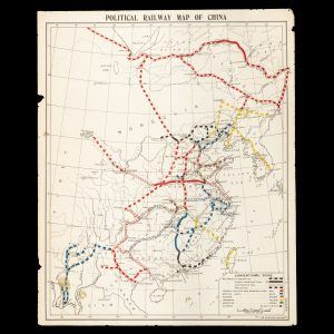
# 46762
FAR EASTERN REVIEW
Political railway map of China
[Shanghai] : Far Eastern Review, circa 1914. Map, printed in colour, 520 x 425 mm (sheet), a couple of small chips and edges and small stains lower left, showing the railways of China which are operational, under construction, contracted for, and projected, under French, Belgian, Russian, British, German, Japanese, American and Chinese control. The train …
-

# 29256
STUART, J. McDouall (1815-1866)
J. M’Douall Stuart’s explorations across the continent of Australia. With charts. 1861 – 62.
Melbourne : F. F. Bailliere, 1863. First edition. Octavo, lettered pink papered cards (lightly discoloured), cloth spine, pp. [vi, advertisements], folding map (short tear at gutter), title page, 97; [3]; occasional foxing. Account of Stuart’s fifth and sixth expeditions from Adelaide to the north of Australia in search of new grazing land and a passage …
-
# 47194
DEKKER, Elly et al.
Globes at Greenwich : a catalogue of the globes and armillary spheres in the National Maritime Museum, Greenwich
Elly Dekker ; with contributions from Silke Ackermann … [et al.] ; edited by Kristen Lippincott, Pieter van der Merwe, and Maria Blyzinsky. Oxford ; New York : Oxford University Press and the National Maritime Museum, 1999. Quarto, buckram in illustrated dustjacket, light handling marks, slipcase slightly marked, pp. xi, 592, illustrations and maps. An …
-
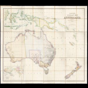
# 43594
JOHNSTON, Keith, 1844-1879
Stanford’s Library Map of Australasia constructed by A. Keith Johnston F.R.S.E., F.R.G.S. &c.
Cover title: Stanford’s map of Australasia. London : Edward Stanford, [1859]. First edition. Steel-engraved map with hand colouring, total dimensions 1550 x 1740 mm, dissected into 48 sections, laid onto linen edged with blue silk, folding to 255 x 215 mm, housed within original embossed brown morocco boards with gilt lettering and ornament (rubbed, spine …
-
![[GLOBE] The earth.](https://dsfb-wp.s3.ap-southeast-1.amazonaws.com/app/uploads/2017/09/12135100/2017_DSFB_4619-250x300.jpg)
# 47150
KLINGER, J. G. (firm)
[GLOBE] The earth.
Published by J. G. Klinger in Nuremberg. Constructed, delineated and etched by J. A. Buhler. Nuremberg : J[ohann]. G[eorg]. Klinger, [between 1841 – 1852]. Wooden and plaster globe (6 inches in diameter), covered with 12 glazed and hand-coloured gores, fitted and spinning with metal polar axis in a circular card box, the lid provided in …
-
# 46524
MARTIN, Robert Montgomery (1801 - 1868)
The British Colonies; their history, extent, condition, and resources
By Montgomery Martin, Esq., late Treasurer to the Queen at Hong-Kong; and member of Her Majesty’s Legislative Council in China. London and New York : The London Printing and Publishing Company [J. & F. Tallis], circa 1851. Six volumes bound in twelve (which are labelled as ‘Divisions’), quarto, publisher’s original gilt-lettered and decorated red cloth …
-
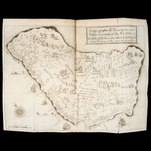
# 43061
LIGON, Richard (1585? - 1682)
A true and exact history of the Island of Barbadoes.
Illustrated with a map of the island, as also the principal trees and plants there, set forth in their due proportions and shapes, drawn out by their several and respective scales, together with the ingenio that makes the sugar, with the plots of the several houses, rooms, and other places, that are used in the …
-
![[MAP] How to get about in Cairo](https://douglasstewart.com.au/app/uploads/2025/03/2025_DSFB_1839-300x300.jpg)
# 46814
CASINO FONTANA (Cairo)
[MAP] How to get about in Cairo
At head ad foot of title: Fontana … with the compliments of the management. [Cairo : Casino Fontana, Manial al-Roda, c.1960]. Single sheet, 490 x 350 mm, folding to 170 x 125 mm; recto with several b/w photographic illustrations, including a panoramic shot of the Casino Fontana, verso with large colour map of Cairo (indicating the …
-

# 29462
LEICHHARDT, Ludwig (1813-1848)
Journal of an overland expedition in Australia from Moreton Bay to Port Essington, a distance of upwards of 3000 miles, during the years 1844-1845.
London : T. & W. Boone, 1847. First edition. Octavo, bound in period style with half-calf over marbled papered boards, spine in compartments with contrasting morocco title labels, pp. xx, 544, 8 (publisher’s advertisements); frontispiece and [6] aquatint plates (1 folding), internally clean; with the rare separately issued, hand-coloured map on three sheets (as issued: …
-
![[MAP] Plan de terrains appartenant à la Société Foncière du Paraguay](https://douglasstewart.com.au/app/uploads/2025/02/2025_DSFB_1621-300x300.jpg)
# 45874
KRIESS, Frederico
[MAP] Plan de terrains appartenant à la Société Foncière du Paraguay
Paris : Maison Andriveau-Goujon, [c.1906]. Colour map, 1000 x 860 mm, dissected and laid on canvas; the map is in superb condition and folds into its original pebbled cloth chemise, 175 x 260 mm, which in turn is housed in the original cloth slipcase (mild edge and corner wear) with contrasting title piece lettered in …
-
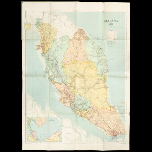
# 46016
Surveyor General
Malaya 1950
[Kuala Lumpur] : Surveyor General, Malaya, 1950. Map, printed in colour, 990 x 720 mm (sheet), laid on linen, in plain card boards, fine. A highly detailed map of the newly formed Federation of Malaya on (established 1 February 1948), including the separate state of Singapore, with an inset map ‘Malaya and adjacent territories’.
-
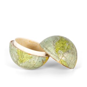
# 46467
Z. & B.
“Globe terrestre” (a box in the form of a pocket globe)
Paris? : Edit. Z & B. c.1910. Card box in the form of a pocket globe, 3 1/2 inches in diameter, the box in two halves split along the equator, which fit together to form the whole, some surface rubbing and detachment of the card inserts internally, a good example.