
Cartography
-

# 20851
THOMPSON, Henry Augustus
The world
[England] : Henry Augustus Thompson, 1853. Manuscript and watercolour map on card with the blindstamp of de la Rue Co, London, 450 x 570 mm (sheet), light surface soiling, old pin holes to corners, fine. A charming and unique manuscript map of the world in two hemispheres, with detailed decorative border vignettes and original hand colour. …
-

# 20658
Victoria showing portions of the adjacent colonies of New Sth. Wales, Sth. Australia and Tasmania
Compiled & engraved at the Department of Lands & Survey, Melbourne, under the direction of A.J. Skene, M.A. Surveyor General ; James Slight, engraver. Melbourne : Department of Crown Lands and Survey [circa 1876]. Engraved map, dissected and laid on linen, 980 x 1340 mm, inset map of Australia, occasional light foxing, in publisher’s cloth case …
-

# 20521
Hawaii. The big island of the Hawaiian group
Honolulu : Hawaii Tourist Bureau, circa 1950. Single sheet, folded to make a tourist brochure on the Big Island, map.
-

# 10896
BETTS, John
Betts’s new map of the world, neatly dissected
London : John Betts, c. 1850. Cedar box with sliding lid featuring an engraved vignette with people and animals from the four great continents, printed advertisement for Betts’s ‘Instructive juvenile games’ on underside, containing the engraved map ‘Betts’s school atlas of the world on Mercator’s projection’, measuring 295 x 450mm, laid on wood and dissected …
-

# 19293
Fiji islands
[Sydney : Picturesque Atlas Publishing Company, 1886]. Chromolithograph map, 430 x 625 mm (sheet), inset map of Australia and the South Pacific, tape reinforcement to fold verso. Issued in the Picturesque Atlas of Australasia (1886)
-
![五大州知恵板 (五大洲智惠板) [Godaishū Chie no Ita] (The Puzzle of the 5 Continents)](https://dsfb-wp.s3.ap-southeast-1.amazonaws.com/app/uploads/2018/05/31145048/2018_DSFB_2073-300x245.jpg)
# 18615
Hōshūdō (publisher)
五大州知恵板 (五大洲智惠板) [Godaishū Chie no Ita] (The Puzzle of the 5 Continents)
[Tokyo] : Published by宝集堂(寳集堂) [Hōshūdō], [1873] (Meiji 6). Colour woodblock print, 660 x 820 mm, 220 x 135 mm (folded); bound in the original yellow wrappers with title slip labeled 五大洲智恵能以多; in fine condition. This map shows the outline of the major landmasses of the world. At the time, there was a school of thought …
-

# 18832
DINGLE, Edwin (editor)
Index to the new map of China (In English and Chinese)
Compiled and translated by the members of the staff of the Far Eastern Geographical Establishment. With a geographical survey of China written specially for this work. Shanghai : Far Eastern Geographical Establishment, 1916. Third edition. Quarto, gilt-lettered cloth (small split to spine), pp. vi; 72, text in English and Chinese. Includes a geographical description of …
-

# 18140
GILBERT, James
Gilbert’s new map of the world, 1850
London : J. Gilbert. Folding map of the world, measures 47 x 94 cm, original hand colour, dissected and laid on linen, a few panels lifting, a few stains. An attractive coloured world map in hemispheres, the spandrels incorporating a comparative chart of the principal mountains throughout the world; comparative charts of the principal rivers …
-

# 18308
CUMMINGS, J.A.
School atlas to Cummings’ Ancient & Modern Geography
Boston : Cummings and Hilliard, [c.1820]. Sixth edition. Octavo, printed wrappers, double page folding world map, double page maps of North America, the United States, South America, Europe, Britain, Asia and Africa, outline hand colour, occasional toning but very good.
-

# 17766
BUTSON, W.J.; VICTORIA. DEPT. OF LANDS AND SURVEY
Tourist map of Geelong and district
Melbourne : Govt. Printer, [1924]. Colour map, 540 x 460 mm, scale [1:126 720] 2 miles to 1 inch; folding to 257 x 103 mm, verso with 12 panels of informative text and sepia tone photographic illustrations; a couple of short tears at edges of folds, one corner a little dog-eared, but a good copy. …
-
![官許 新刊輿地全圖 [Kankyo shinkan yochi zenzu] [Officially Licenced New Map of the World]](https://dsfb-wp.s3.ap-southeast-1.amazonaws.com/app/uploads/2016/09/16102758/2016_DSFB_51121-300x298.jpg)
# 14378
竹口瀧三郎 [Takeguchi Takisaburō]; 上村福三郎 [Uemura Fukusaburō]
官許 新刊輿地全圖 [Kankyo shinkan yochi zenzu] [Officially Licenced New Map of the World]
Edo (Tokyo), Japan : 萬屋兵四郎 [Yorozuya Heishirō], [1862] (Bunkyū 2). Hand coloured woodblock print, original cloth covers and paper portfolio, both with title labels (portfolio with some silverfishing and lacking left-hand flap), map with some foxing and silverfishing, repaired with Japanese tissue. A detailed map of the world on Mercator’s projection bordered by vibrantly coloured …
-
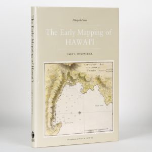
# 16833
FITZGERALD, Gary L.
The early mapping of Hawai’i
With contributions by Riley M. Moffat. London : Kegan Paul International, 1987. Folio, lettered cloth, illustrated dustjacket, pp. 160, extensively illustrated with maps, a fine copy. Includes chapters on Captain Cook and the maps of early missionaries.
-
![新訂 坤輿略全圖 [Shintei konyo ryaku zenzu] [Newly-edited General Map of the World]](https://dsfb-wp.s3.ap-southeast-1.amazonaws.com/app/uploads/2016/08/14135137/2016_DSFB_5140-300x143.jpg)
# 14199
新發田収藏 [Shibata Shūzō], 竹口貞齋 [Takeguchi Teisai]
新訂 坤輿略全圖 [Shintei konyo ryaku zenzu] [Newly-edited General Map of the World]
Edo [Tokyo], Japan : 高木耕藏 [Takagi Kōzō], Kaei 5 [1852]. Hand coloured woodblock print, original covers with facsimile title label, map with some silverfishing, repaired with Japanese tissue. A pseudocylindrical projection map showing the world centred on Japan. Includes preface by written by 北海半嶋漁人 [Hokkai Hantō Ryōjin] and legend with date and publisher information. 新發田収藏 [Shibata Shūzō] …
-
![新製 輿地全圖 [Shinsei yochi zenzu] [Newly-produced Map of the World]](https://dsfb-wp.s3.ap-southeast-1.amazonaws.com/app/uploads/2016/08/16112220/2016_DSFB_5178-300x144.jpg)
# 14118
ed. 箕作省吾 [Mitsukuri Shōgo]
新製 輿地全圖 [Shinsei yochi zenzu] [Newly-produced Map of the World]
[Japan] : [s.n.], Kōka 1 [1844]. Scroll housed in modern box, 1365 x 347 mm, silverfishing repaired with Japanese tissure throughout. Shows eastern and western hemispheres with preface by 大槻盤溪 [Ōtsuki Bankei] (1801-78), a Confucian scholar and the instructor of the western gunnery at the Sendai Domain. Following the map is a legend written by 箕作省吾 …
-

# 15651
Map of Singapore
With compliments of Thomas Cook & Chanrai’s, Singapore’s only exclusive air conditioned men’s shop. Singapore : Thomas Cook, c. 1950. Folding map, printed in colour, 450 x 295, guide to Singapore and advertisements verso. Fine condition.
-
![[Administrative atlas of Vietnam]. Tập bản đồ Việt Nam. Hành chính và hình thể.](https://dsfb-wp.s3.ap-southeast-1.amazonaws.com/app/uploads/2017/05/24162830/2017_DSFB_1607-300x300.jpg)
# 15498
[Administrative atlas of Vietnam]. Tập bản đồ Việt Nam. Hành chính và hình thể.
Hà Nội : Cục đo đạc và bản đồ nhà nước, 1986. Octavo, illustrated wrappers, pp. 24, printed in colour. Atlas of Vietnam including the South China Sea, with inset maps of Ho Chi Minh City and Ha Noi. Scarce. Four copies located on WorldCat (all in central European collections).