
Cartography
-

# 44499
BARTHOLOMEW, J[ohn], W. HUGHES, and Sidney HALL (engravers)
Atlas of Australia with all the Gold Regions
A series of maps from the latest and best authorities. Edinburgh : Adam and Charles Black, c. 1853. Quarto, later gilt-lettered cloth, containing six hand-coloured engraved maps (five double page, and one folding) of the gold regions of Australia, a few pale stains, short tape repair to the margin of the first map, and a …
-

# 43895
LETTS, SON & CO. LTD.
Letts’s map of The Soudan, including the Nile, Red Sea, West Coast of Arabia, and Abyssinia, and a Plan of Khartum.
One Shilling. [Drop title]. London : Letts, Son & Co. Ltd., Map Publishers, 33 King William Street, London Bridge, [c.1885]. Third edition. Cased colour map titled ‘Letts’s Map of The Nile, embracing The Soudan, Abyssinia, the Red Sea, and Western Arabia’, 740 x 560 mm (sheet), folding to 200 x 100 mm, housed within in the …
-

# 31523
PHILLIP, Arthur (1738-1814)
The Voyage of Governor Phillip to Botany Bay (first edition, coloured)
with an account of the establishment of the Colonies of Port Jackson & Norfolk Island; compiled from authentic papers, which have been obtained from the several departments, to which are added, the journals of Lieuts. Shortland, Watts, Ball, & Capt. Marshall; with an account of their new discoveries. London : John Stockdale, 1789. Quarto, contemporary …
-
![[COOK] Newton’s new & improved terrestrial pocket globe 1817](https://douglasstewart.com.au/app/uploads/2023/06/2023_DSFB_3248-300x300.jpg)
# 40260
NEWTON FAMILY
[COOK] Newton’s new & improved terrestrial pocket globe 1817
London : John Newton, 1st January 1817. Terrestrial pocket globe, 3 inches in diameter, engraved gores with original hand colour over papier-mâché and plaster sphere, the surface in fine order with a recent wax applied for protection, two metal pins resting the globe in the original publisher’s shagreen case, titled Newton’s improved pocket celestial globe, …
-

# 43742
LORING, Josiah (1775 - c. 1840)
Loring’s nine and half inch terrestrial globe.
Drawn and engraved by W, B. Annin. Boston : Josiah Loring, [c.1845]. Terrestrial globe, 9 1/2 inches in diameter, engraved gores and two polar calottes with original hand colouring over papier mache base, graduated equator, ecliptic and date line meridian, the oceans with an analemma showing the delineation of the sun for every day of the …
-

# 43860
THURY & BELNET
Globe en relief par Thury & Belnet
MÉDAILLE DE 2é CLASSE, EXPOSITION DE PARIS, 1855. Mèd.le de 1re Classe, Expon de Dijon 1858. – Méd.le d’Or Acadmie de Dijon BREVET D’INVENTION S.C.D.C. GLOBE EN RELIEF PAR THURY & BELNET GÉOGRAPHES, AUTEURS, ÉDITEURS, DIJON. Lith. Richard Dijon. Dijon : Thury & Belnet, circa 1860. Terrestrial globe titled Globe en relief, 12 inches in diameter, …
-

# 42545
THE EVENING NEWS
The Evening News London “Tube Map”
London : George Philip & Son, c. 1910. Folding map, 50 x 61 cm, with map of London Tube stations recto, map of the tramways verso, printed in colour; some slight mis-creasing, edge discolouration, very short edge tears at folds; a very good copy, housed in printed card case. A rare early printed map of …
-

# 43858
FOREST, J.
Globe terrestre (6-inch)
[Paris] : J. Forest, [c.1925]. Terrestrial globe titled Globe terrestre, 6 inches in diameter, lithographed gores over papier-mâché sphere, metal pins on a turned French ebonised wooden stand, original, a few light marks and foxing, a small impression in the Pacific. A good example of an uncommon table globe from the interwar period, showing the …
-
![[OTTOMAN WORLD ATLAS] Ilk atlas. Ilk mekteblere mahsus.](https://douglasstewart.com.au/app/uploads/2024/06/2024_DSFB_3165-300x300.jpg)
# 43948
FAIK SABRI [DURAN] (1882-1943)
[OTTOMAN WORLD ATLAS] Ilk atlas. Ilk mekteblere mahsus.
[=First atlas for primary schools]. London : Corc Filip ve Mahdumu Limited Matbaasi [George Philip & Son], 1927. Large octavo (240 x 200 mm), original cloth-backed limp paper boards (water and ink stains, pronounced vertical crease); pp. 16, with 15 chromolithographed maps; text in Ottoman script (Old Turkish with Arabic letters); all leaves with vertical …
-

# 43721
ECCLESTON, Gregory C.
Granville Stapylton : Australia Felix 1836 : second in command to Major Mitchell
Melbourne : Evandale Publishing, 2018. Oblong quarto, boards in dustjacket, pp. xix; 250; 46 pages of plates, a fine, new copy. “Granville Stapylton Australia Felix 1836 Second-in-command to Major Mitchell is based on the true journals of the pioneer land surveyor Granville Stapylton when he accompanied Major Thomas Mitchell on the famous ‘Australia Felix’ expedition …
-
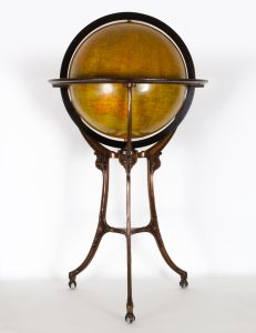
# 40253
JOHNSTON, W. & A. K.
18-inch terrestrial globe
London and Chicago : W. & A. K. Johnston for Hammett, circa 1910. Measuring 18 inches (46cm) in diameter, 45 inches (115 cm) tall; in bronzed cast iron meridian and stand, with calendrical paper horizon ring, laid on wood; with an analemma and two polar calottes. Standing in bronzed cast iron tripod stand with glass …
-

# 42870
J. FOREST
Globe terrestre
[Paris] : J. Forest, [c.1935]. Terrestrial globe titled Globe terrestre, 6 inches in diameter, lithographed gores over papier-mâché sphere, metal pins on a turned French ebonised wooden stand, original, with distressed finish. A good example of an uncommon table globe from the interwar period, showing the geographical names Leningrad, Istanbul, Iran and Mandchukuo, dating it …
-
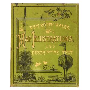
# 43058
WALKER, Richard Cornelius Critchett (1841-1903)
New South Wales : map, illustrations and descriptive text.
[Cover title]. Sydney : Thomas Richards, Govt. Printer, 1884. Quarto (290 x 240 mm), publisher’s pictorial green cloth over boards with bevelled edges, the upper board with blind-blocked decoration and lettering in gilt and black (scattered light staining), inside upper board with contextual map of the Eastern Hemisphere illustrating shipping routes from London to Sydney, …
-

# 26028
LAMP, Jean-Frédéric
Abrégé de géographie pour les écoles.
Par J. F. Lamp. A Paris : Chez F. G. Levrault, libraire, rue de la Harpe, no. 81 ; Strasbourg : rue des Juifs, no. 33, 1833. Troisième édition. Duodecimo (165 x 105 mm), original pink paper-covered boards printed in black, the upper board with vignette illustration of a globe, lower board with publisher’s advertisements, …
-
![[MAPS] 万国地誌略諳射訳図 (萬國地誌略諳射譯圖)(萬國地誌畧諳射譯圖) [Bankoku Chishiryaku Ansha Yakuzu]](https://dsfb-wp.s3.ap-southeast-1.amazonaws.com/app/uploads/2018/05/31145003/2018_DSFB_2064-300x300.jpg)
# 18614
山田申太郎 (Yamada Shintarō) & 高原徹也 (Takahara Tetsuya), edited by 日原昌造 (Hihara Shōzō).
[MAPS] 万国地誌略諳射訳図 (萬國地誌略諳射譯圖)(萬國地誌畧諳射譯圖) [Bankoku Chishiryaku Ansha Yakuzu]
Complete set of 6 copperplate engraved maps with hand colouring. Maps 1-4 published by 岡安慶介 (Okayasu Keisuke) [1878] (Meiji 11); Maps 5 & 6 published by 桑原伊之助 (Kuwabara Inosuke) [1880] (Meiji 13). 1. Asia, the Middle East, and Russia east of the Urals (340 x 400 mm); 2. Africa (310 x 260 mm); 3. Europe, with Russia …
-
![輿地新. [Yochi shinzu furoku]. [Supplement to the Map of the World].](https://dsfb-wp.s3.ap-southeast-1.amazonaws.com/app/uploads/2018/05/31155048/2018_DSFB_2093-300x300.jpg)
# 18584
BERGHAUS, Hermann; 村田文夫 [MURATA, Fumio, translator]
輿地新. [Yochi shinzu furoku]. [Supplement to the Map of the World].
Kyoto, Osaka, and Tokyo: 勝村治右衛門 [Katsumura Jihei], 柳原喜兵衛 [Yanahara Kihei], 北畠茂兵衛 [Kitahata Mohei] et al.. 1874. Two volumes, small quarto (250 x 180 mm), Japanese 5 hole stab binding, original yellow paper covers (rubbed) and title labels; with volvelle showing the earth’s orbit, 3 double page copper engraved colour maps, and numerous black and white maps and …