
Cartography
-
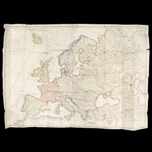
# 40002
NOLLIN, J. B.
Carte politique de l’Europe, divisée en ses principaux états
Dressee pour l’Instruction et sur les dernières Observations Astronomiques par J. B. Nollin, Ingénieur Géographe. Revue et corrigée par J. B. Poirson. Paris : chez Jean, 1802. Copperplate engraved map on paper, 750 x 1080 mm (sheet), folded, manuscript title verso, original hand colouring in outline, a couple of small holes at the corners of …
-
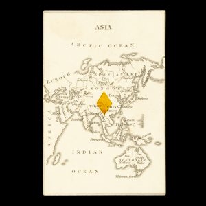
# 24932
ROCK, William and Henry
Playing card with map of Asia including Australia
[London : William & Henry Rock, 1839]. Single playing card (from the deck of 52), 97 x 65 mm, verso blank, recto with engraved map of Asia stretching fro the Arctic Ocean to Van Diemen’s Land, the Australian continent divided between New Holland and New South Wales, with coloured diamond in the centre. From the …
-
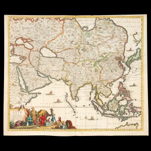
# 39617
de WIT, Frederick (1630-1706)
Accuratissima totius Asiae tabula : in omnes partes divisa, de nova correcta, ac in lucem edita
per Fredericum de Witt Amstelodami cum privilegio D.D. ordinum Hollandiae Westristacqs ; F. de Wit excudit. [Amsterdam : Frederik de Wit, circa 1688]. Copperplate engraving on paper, 58.0 cm in diameter, on sheet 51.0 x 61.0 cm, original hand colouring, a couple of paper reinforcements verso, a very good copy. A fine large format seventeenth century …
-
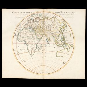
# 39616
de L'ISLE , Guillaume (1675 - 1726)
Orbis veteribus noti tabula nova
Auctore Guillelmo Del’Isle e Regia Scientiarum Academia et Christianissimi Francorum Regis Geographo primario. Amstelodami : apud I Covens et C. Mortier, [circa 1741]. Copperplate engraving on paper, 46.4 cm. in diameter, on sheet 53.5 x 65.5 cm, coloured by hand, central fold as issued, small paper reinforcement verso, lightly marked, a fine example. An impressive, large …
-

# 37954
TARDIEU
Les cinq parties du monde
Planisphère comprenant toutes les possessions coloniales, chemins de fer, lignes de navigation. Paris : Tardieu, circa 1920. Very large folding map of the world printed in colour, 97 x 129 cms, wear with some loss along the folds, a striking large format world map.
-

# 37748
BARTHOLOMEW, J.
The world on Mercator’s projection
[Cover title : Mercator’s world. Philips’ series of travelling maps]. London : George Philip & Son, circa 1900. World map on Mercator’s projection, printed in colour, dissected and laid on linen, 52, x 63 cms, housed in gilt-lettered cloth case. The map shows Alexandra Land in the Northern Territory, and the ‘Supposed Antarctic Continent’.
-

# 35845
Rand McNally & Co.
Rand McNally 18″ Globe
[Chicago] : Rand McNally & Co., circa 1928. Chromolithographed paper gores over paper mache base, 18 inches in diameter, oval shaped analemma, engraved brass meridian, wooden horizon ring with paper calendar, four cross-stretchers, on the original Regency revival stand turned wood on tripod base, the legs ending with brass clawed feet A fine, handsome American …
-
![[SNOWY MOUNTAINS] Alpine and Southern District for the tourist. New South Wales, Australia.](https://dsfb-wp.s3.ap-southeast-1.amazonaws.com/app/uploads/2022/11/25173448/2022_DSFB_7608.jpg)
# 37994
NEW SOUTH WALES GOVERNMENT TOURIST BUREAU; WESTON, Harry (illustrator)
[SNOWY MOUNTAINS] Alpine and Southern District for the tourist. New South Wales, Australia.
[Drop title]. Sydney : produced by the New South Wales Government Tourist Bureau ; printed by Posters Pty. Ltd, June 1938. Large folding sheet, 400 x 700 mm, folding to 210 x 140 mm, printed on both sides, recto with [8] panels each with b/w photographic illustration and text, and [2] panels forming the colour-illustrated …
-

# 37788
GEORGE PHILIP & SON
Philips’ 6 inch terrestrial globe
London : George Philip & Son, circa 1930. Terrestrial globe 6 inches in diameter, printed gores over plaster base, graduated equator band, supported on a contemporary half-meridian stand on turned wooden base, some old surface rubbing, with a recently applied varnish, a very good example. An interesting interwar terrestrial globe, showing the renamed cities of …
-
![[MAP; WIMMERA] Booroopki, County of Lowan](https://dsfb-wp.s3.ap-southeast-1.amazonaws.com/app/uploads/2022/09/14144356/2022_DSFB_5609.jpg)
# 36432
VICTORIA. DEPARTMENT OF LANDS & SURVEY
[MAP; WIMMERA] Booroopki, County of Lowan
Photo-lithographed at the Department of Lands and Survey, Melbourne, by W. J. Butson, 7.7.14. Lithographed map, single sheet, 675 x 400 mm, folding to 280 x 102 mm; manuscript title to front ‘Booroopki’; a couple of short tears at junctions of the folds, otherwise very good. Pre-World War One map showing land subdivisions (with owners’ …
-

# 28901
BOWLES AND CARVER
Bowles’s new one sheet map of Asia, divided into its Empires, Kingdoms, States, and other subdivisions; laid down from observations of the most celebrated geographers.
London : Bowles and Carver, 1801. Engraved map with original hand colouring, laid on wood and dissected, three blank replacement pieces (the lost pieces in the regions of Java, Sumatra and Hokkaido), the assembled map measuring 485 x 582 mm, housed in the original cedar box with sliding lid, letterpress title label. A fine early …
-

# 15370
Tulloch & Brown’s map of the Colony of Victoria :
comprising part of New South Wales, the boundaries, counties, also seaport & inland townships, the gold fields with the latest discoveries, roads, tracks, &c. &c. Compiled from drawings in the Survey Office and correctly revised till 1857. Melbourne : Tulloch & Brown, 1857. Engraved map with original hand colouring (foxed), 550 x 860 mm, laid …
-

# 19849
d'ANVILLE, Jean-Baptiste Bourguignon (1697-1782)
Atlas général
[Paris : circa 1780]. Elephant folio, 28 x 18 inches (730 x 465 mm), full green morocco, floral gilt decoration to edges, spine in compartments and lettered in gilt with contrasting red morocco title label (rebacked onto vellum with some early restoration to the upper portion), gilt stamped bee designs to the compartments of the …
-

# 16154
Weber and Costello Co.
An 18 inch table globe
Chicago, Illinois : Weber Costello, [c.1925]. Measuring 18 inches (46cm) in diameter. Terrestrial globe shows the city of Leningrad, changed from Petrograd in 1924, but noticeably lacking the state of Central Australia, which existed between 1927-1931. In bronzed cast iron meridian and stand, with sympathetic facsimile calendrical paper horizon ring, laid on wood. With an …
-

# 23510
EVANS, George William, (1780-1852)
Voyage a la terre de Van Diemen, ou, Description historique, géographique, et topographique de cette ile.
[Series : Collection des meilleurs voyages modernes, Tome 40]. Paris : Bureau des Annales des Voyages, 1823. Octavo, contemporary blue paper wrappers, pp. [iv – prospectus for Ternaux-Compans’ Archives des voyages], 187; [2 – catalogue for Librairie de Gide Fils, with an advertisement for this title], folding frontispiece plate with engraving of Hobart by Engelmann, large …
-

# 35142
CRAIG, Clifford
Notes on Tasmania
Launceston : Foot & Playsted, 1986. Edition limited to 1000 numbered and signed copies (no. 106). Large octavo, pictorial cloth boards in dust jacket, xvii, 324 pp, illustrated with 45 plates (some colour); light foxing to edges and preliminaries, light tape marks to endpapers, a very good copy with the scarce prospectus loosely enclosed.