
Cartography
-
# 46762
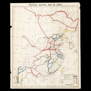
FAR EASTERN REVIEW
Political railway map of China
[Shanghai] : Far Eastern Review, circa 1914. Map, printed in colour, 520 x 425 mm (sheet), a couple of small chips and edges and small stains lower left, showing the railways of China which are operational, under construction, contracted for, and projected, under French, Belgian, Russian, British, German, Japanese, American and Chinese control. The train …
-
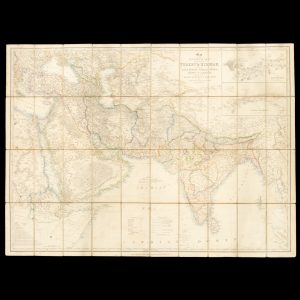
# 49554
WYLD, James
Map of the countries lying between Turkey & Birmah, comprising Asia Minor, Persia, India, Egypt & Arabia, and including the Black, Caspian & Red Seas
[Cover title : Map of the countries between Turkey & Burmah, comprising Turkey, Egypt, Arabia, Persia, Bokhara and India, and particularly contract dot show the Overland Route to India]. London : James Wyld, 1839. Engraved map with original outline hand colouring, dissected and laid on linen, 78.5 x 10⁸ cms, a few light stains, printed …
-
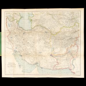
# 49439
GEORGE PHILIP & SON
Persia, Afghanistan and Baluchistan
Philips’ Authentic Imperial Maps for tourists & travellers series. London : George Philip and Son, circa 1920. Map printed in colour, 540 x 660 mm, laid on linen and folded into publisher’s lettered cloth case, advertisements to panels, colour pencil circles around some major cities in Persia and the route of a journey taken from …
-
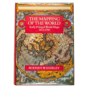
# 49459
SHIRLEY, Rodney W.
The mapping of the world. Early printed world maps 1472 – 1700
London : The Holland Press, 1987 (reprint, with corrections). Folio, cloth in dustjacket, pp. xlvi; [ii]; 669, illustrated. A very good copy. The standard bibliographic reference for world maps of the period, an essential reference.
-
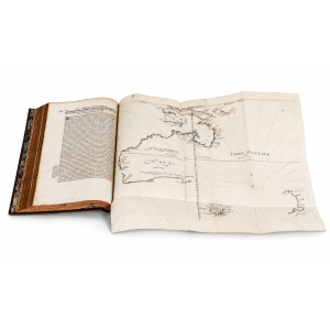
# 48825
THÉVENOT, Melchisédec (1620-1692)
Relations de divers voyages curieux,
qui n’ont point esté publiees, ou qui ont esté traduites d’Hacluyt, de Purchas, & d’autres Voyageurs Anglois, Hollandois, Portugais, Allemands, Espagnols; et de quelques Persans, Arabes & autres Orientaux. Enrichies de Figures de Plantes non décrites, d’Animaux inconnus à l’Europe, et de Cartes Geographiques de Pays dont on n’a point encore donné de Cartes. Paris : Jacques Langlois, …
-
![[CASED POCKET ATLAS; REVOLUTIONARY WAR]. [Almanach géographique ou petit atlas élémentaire ...]](https://douglasstewart.com.au/app/uploads/2024/01/2024_DSFB_0294-300x300.jpg)
# 42554
[DESNOS, Louis-Charles]
[CASED POCKET ATLAS; REVOLUTIONARY WAR]. [Almanach géographique ou petit atlas élémentaire …]
[Paris : Desnos, circa 1771]. Thirty-two copperplate engraved maps, each measuring 95 x 95 mm (image) and 115 x 115 mm (sheet), numbering in the upper right corner of each map; laid on linen, overall measurements 470 x 940 mm; inscribed verso Presented by the Marquis St. Simon to A. Gordon, with the initials M. G. (another …
-

# 13956
CRUCHLEY, G[eorge] F[rederick] (1797 - 1880)
Cruchley’s new map of the world (on Mercator’s projection),
shewing the tracks of the principal modern navigators, and including the new discoveries by Flinders, Hall, Ross, Parry, Franklin, Clapperton, Denham, Larnder &c. London : G. F. Cruchley, c. 1834. Engraved map with original hand colouring, dissected and laid on linen, 550 x 670 mm, in original publisher’s marbled paper case with printed label and publisher’s …
-
![[CHILDREN’S GAME] Voyage dans les cinq parties du monde.](https://dsfb-wp.s3.ap-southeast-1.amazonaws.com/app/uploads/2022/05/30143312/2022_DSFB_4158-300x300.jpg)
# 35516
BUSSIÈRE (publisher); MATENET, Jules Xavier (designer); COUDERT, B. (illustrator); JANNIN, H. (lithographer)
[CHILDREN’S GAME] Voyage dans les cinq parties du monde.
Paris : Bussière, [between 1870 and 1880]. Original cartonnage box, 235 x 295 x 40 mm, the lid with hand-coloured lithographic onlay of a scene on the Amazon with printed game title above and picture caption below, along with the publisher’s imprint ‘Bussière, Ed. Paris’, framed by an embossed paper border (scattered silver fishing at …
-

# 15660
STANFORD, Edward
Map of Australia
London : Edward Stanford, 26 & 27 Cochspur Street, Charing Cross, [1893]. Chromolithographed map, dissected and laid on linen, overall size 688 x 912 mm, housed in publisher’s cloth slipcase with printed title label, a fine copy. With the routes of many inland explorers (Sturt; Landsborough; Warburton; Giles; Tietkens etc). and inset map showing the telegraph …
-
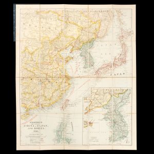
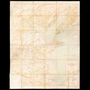
# 47387
STANFORD, Edward
Stanford’s map of Eastern China, Japan and Korea. 1904.
London : Edward Stanford, 1904. Map printed in colour, 675 x 555 mm, dissected and laid on linen, cloth case with paper title label, fine condition. A detailed map showing Japan, Korea, Taiwan, the northern Philippines and the provinces of eastern China, with a large inset map of Korea, and the distances between major cities.
-
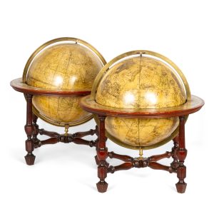
# 43785
BARDIN, William (c.1740-1798)
A matching pair of Georgian terrestrial and celestial table globes
A new, accurate and compleat terrestrial globe, accompanying the Geographical Magazine. Originally laid down by Mr. James Ferguson, F. R. S. Improv’d by G. Wright, and made by W. Bardin, Fleet Street, London. Published as the act directs by Harrison & Co., No. 18 Paternoster Row, Augt. 1st, 1783 (cartouche). Published by G. Wright & …
-
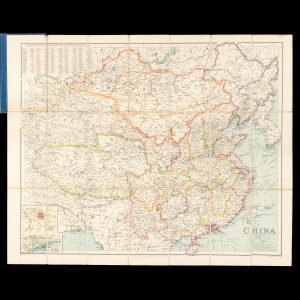
# 49297
GEORGE PHILIP & SON
China
Philips’ authentic Imperial Maps for Tourists and Travellers. London : George Philip & Son, circa 1920. Map, printed in colour, 550 x 670 mm, dissected and laid on linen, in original publisher’s cloth case, inset maps of Peking, HongKong and Canton, showing the steamship routes, caravan routes and railways.
-
# 49319
WAEBER, Ch. (1841 - 1910)
Map of North Eastern China
Chief Depot L. Friederichsen & Co., Hamburg. St. Petersburg : Geographical Establishment of A. Ilyin, 1900. Second edition. Lithographed map, 121 x 96.5 cms, dissected and laid on linen, in plan green cloth boards with binder’s ticket of Kelly & Walsh, Shanghai, spine crudely repaired with cloth tape, contemporary inscription inside upper board ‘I. – …
-
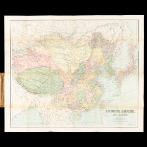
# 49298
PHILIP, George
Chinese Empire, and Japan.
[Cover title: Philips’ authentic map : China]. London & Liverpool : George Philip, c. 1910. Chromolithograph map on paper, folded and pasted into publisher’s cloth case with paper title label, 550 x 660 mm, light foxing, a very good copy. Shows the European territories, railways etc.
-

# 50120
WOODS, Martin et al.
Mapping our world : Terra Incognita to Australia
Canberra, ACT : National Library of Australia, 2013. Oblong quarto, illustrated wrappers, pp. xxix, 256, illustrated. Base of spine bumped with a crack. An extraordinary exhibition of manuscript and printed maps of Australia, the Pacific and the world from the medieval period to nineteenth century.
-
# 48532
D'ENTRECASTEAUX, Antoine Bruni [Bruny] (1737-1793)
Voyage de D’entrecasteaux, envoyé à la recherche de La Pérouse
… / rédigé par M. de Rossel. Paris : De L’Imprimerie impériale, 1808. Two volumes, thick quarto, both text volumes finely bound in uniform full morocco, ruled in gilt, expertly rebacked, spines in compartments with ornamental gilt tooling and lettering, all edges gilt, first volume with half-title, title leaf, pp. lvi, 704 pp with 32 folding …